
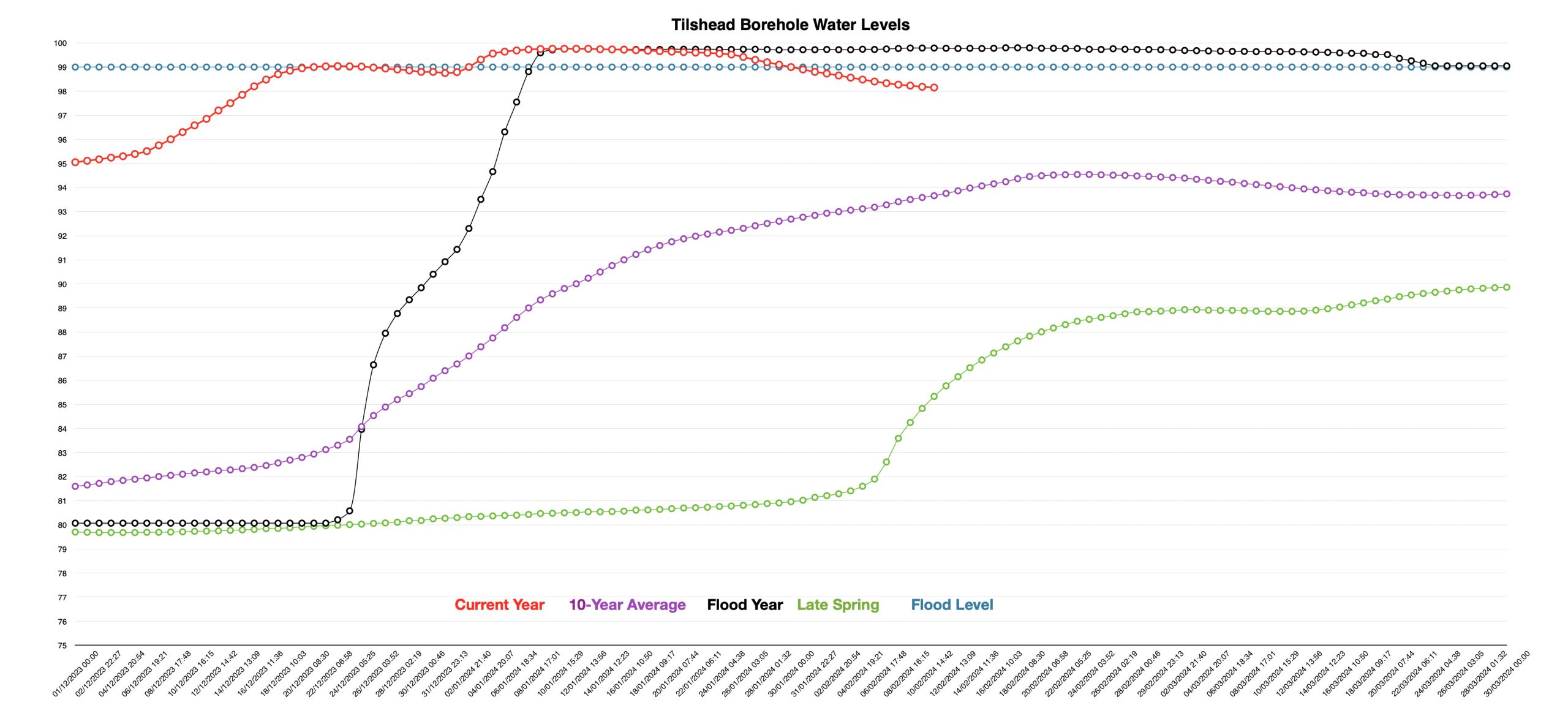
A period with quite a bit of moderate rainfall; just over 40mm for the week. That has been enough to slow the rate of fall in the aquifer water levels, but not to reverse the direction of travel which is still downwards. The River Till levels rose briefly on Thursday and Friday but were falling again by yesterday morning and that trend has continued today. That leaves water levels some 4m above the 10-year average, half a metre above the Environment Agency’s Flood Warning level, but the Flood Alert issued last week has now been removed.
Talking of the Environment Agency, I’ve been in touch with them over the last week as part of an ongoing effort to get the alerts and warnings improved. Back in 2015, dissatisfied with the performance of the current Tilshead borehole for forecasting groundwater flooding, they put in a new borehole around 2km away from the original. It takes around 10 years of data collection to show if this new daughter site is better than the original and now, nearly a decade later, they are about to change to it at the next iteration of their model. That may mean they can offer a bit more accuracy in flooding forecasts, but that may be of greatest benefit to those closest to Tilshead; time will tell.
Now here is where YOU can help. The Environment Agency hopes their groundwater flood model will generate warnings with 5-day lead time. To do this, they need an accurate idea of when the floods first start to have an impact on affected properties. So, whether there has been water bubbling up in your kitchen, flooding outbuildings, or, you have to pump out a sump, add additional pumps to an existing pumping set-up, or have had your septic tank fill with groundwater or river water, the Environment Agency want to know. As a householder, you can report this information to the FORT (Flood on-line reporting tool) website here: https://swim.geowessex.com/glos/Help/about
If you visit this website, you will notice that it has Dorset Council’s name and links plastered all over it. Nowhere will you see Wiltshire Council mentioned; at least not on the front page. However, that is because the Dorset Council Flood Risk Team has driven this project forward in conjunction with the Environment Agency, but it is designed for the whole of the Wessex area, including us here in Winterbourne Stoke. If you click on the first drop-down menu that appears (Record), you can provide information about current flooding or floods that have happened earlier in the year, or, at any time in the last 5 years. So, over to you to give them the information they want. If you can help out with this, then just maybe alerts and warnings will be a bit more timely in the future than they currently are.
As for the weather, we are going to have more in the way of showers today, a brighter day on Monday, with more cloud drizzle and rain for the rest of the week. Some of the rain may be heavy. It’s going to be mild for the time of year and we are likely to see quite a lot of drizzle. As we go forward into late February and early March there is increasing uncertainty about how the weather here in the south will pan out. It’s going to be warm, wet and windy from the south-west, dry and cold from the north-east or a bit of each; you choose.
Contains public sector information licensed under the Open Government Licence v3.0.