
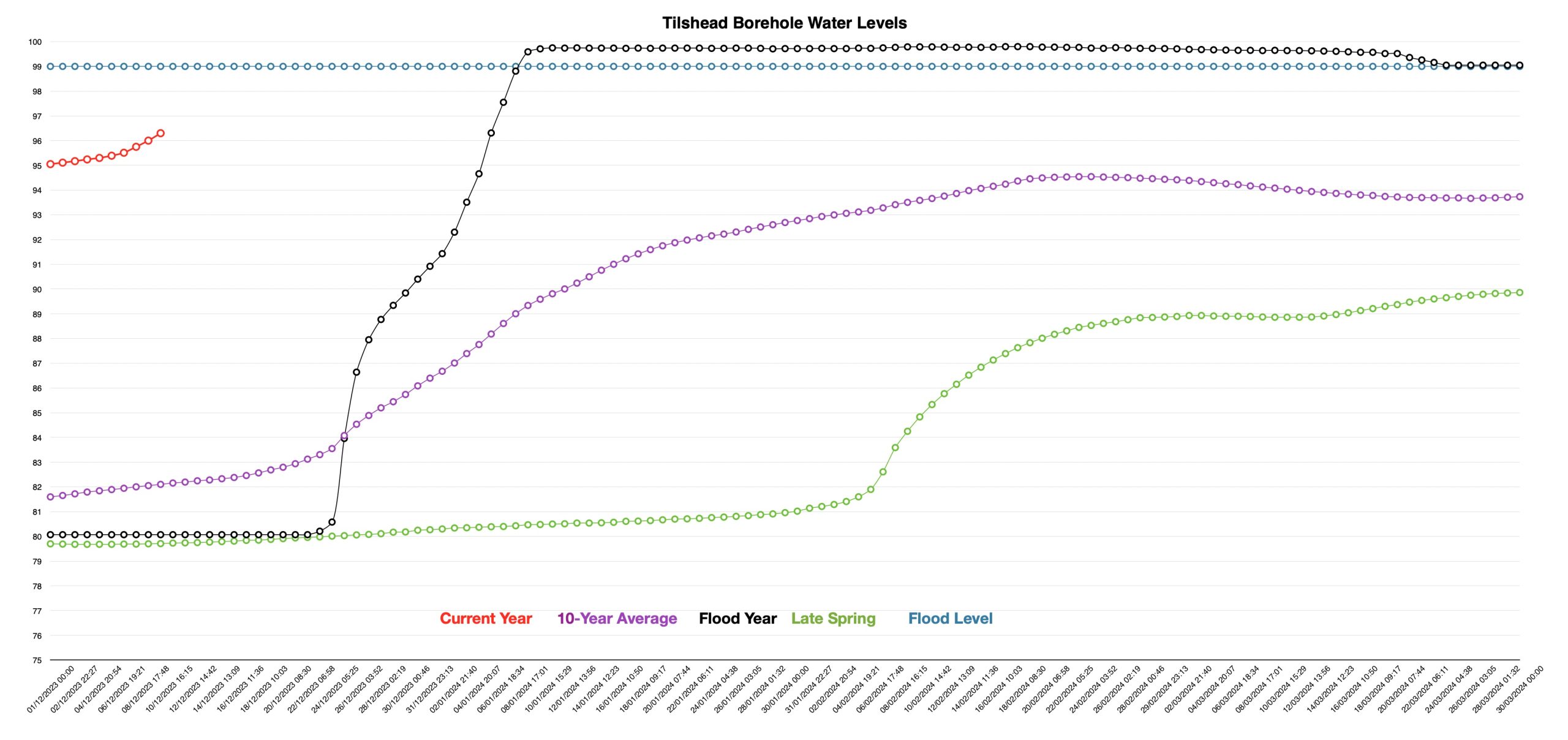
Another week with several rainy days and of course the water level in the Tilshead borehole rose much as anticipated. The rate of rise was slow at first as the rain soaked into the dryish ground, then after around 4 days, the rate accelerated as it often does. Despite the groundwater level now being well above the Environment Agencies Flood Alert trigger level of 95 .00 metres AOD, no groundwater Flood Alert has yet been issued. However, in the last 24 hours the Environment Agency has issued a river Flood Alert for the River Wylye and some of its tributaries, including the River Till. Those of you who watch the river will be aware that the levels have risen, but it’s still 0.3 to 0.5 metres below the level most of us would think of as being a flood; there’s not even enough water around to start flooding the water meadow to the south of the village.
Let’s look at the current groundwater levels in a little more detail and then go back to look at the complex situation of the Tilshead catchment area and the River Till itself. The red line in the top left are the data collected since 1st December and showing the increase in the rate of filling. We are now over 1.5 metres above the average peak winter maximum level for the last decade and over 2 months earlier than we might expect. So winter 2023-2024 is already wetter than average. However, the average level is a bit of a red herring as the current level is pretty much the median maximum depth level of all the 10 annual readings that make up the average.
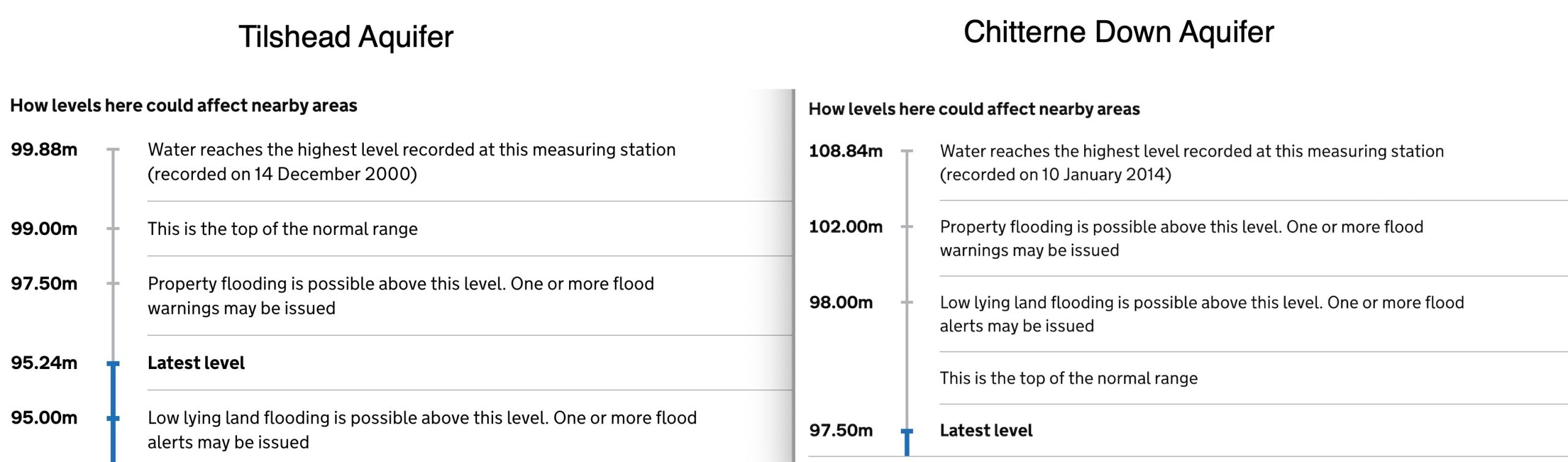
This next chart is one we haven’t shown before, but it might help people get a better idea about how unusual the Tilshead aquifer, and the River Till, as a winterbourne, really are. It may also explain why the Environment Agency invariable gets the Flood Alerts and Warnings late or miss them altogether. These two charts are cut and pasted from the Environment Agency website. The Chitterne Down borehole is just a few hundred metres southwest of the Tilshead borehole and they are effectively opposite sides of the same hill. Ground and surface water falling to the west of Chitterne Down makes its way down valleys and into the Codford Brook; before flowing into the Wylye. Water to the east of the Tilshead borehole moves southeastward and then southwards into the Rivers Till and Wylye.
Now look at descriptions used by the Environment Agency (EA) to describe the Chitterne Down aquifer. It behaves in flood like any other ‘normal’ catchment area for groundwater or rivers. There is a normal range for the water level. Below this you would have drought and above it, a potential flood. So, once the normal level is exceeded, there is a possibility that low-lying land may flood and the EA can issue one or more Flood Alerts. If more water is trapped in the aquifer, there is an increasing risk that property may suffer groundwater flooding and the EA move to issuing Flood Warnings. Finally, you have the highest ever recorded. That is all perfectly logical.
Now look at the description for the Tilshead Aquifer on the left. It is very different indeed. Flooding of low-lying land and even property flooding all start to happen whilst the water level is still well within the normal range. The highest level ever recorded is only marginally greater than the normal level. This may begin to explain why EA are always so slow in issuing groundwater Flood Alerts and Warnings for this area – perversely, the water levels rarely exceed the normal range, so how can you give alerts and warnings when all is normal? That can’t give any comfort to those whose properties are prone to flooding and that is why it’s better to be aware of your local area and its peculiarities and not be reliant on a centralised and very probably automated EA system that can’t cope with exceptions to the rule!
Now the Tilshead borehole isn’t unique in this context, but it is rare and unusual. So far, we have been able to identify one other example in the general area and that is a borehole in Woodyates, Dorset. It may be tempting to think that these anomalies are related to winterbournes, but that doesn’t seem to be the case either. Whilst Woodyates is also associated with a bourne-type stream, other Winterbounes in this area don’t seem to have similar boreholes close to them.
What’s going to happen over the coming period? Well, we have more heavy rain today with more anticipated on Tuesday and Thursday of next week. Heading towards Christmas, the weather is likely to be overcast with more patchy rain. As we move towards the New Year, the weather is going to be mild and wet.
Contains public sector information licensed under the Open Government Licence v3.0.