
“Don’t Panic!” remains the theme of this week’s flood watch; at least not yet. I realise that over the last decade, and particularly over the last year or so, we’ve had quite a turn round of villagers who may be unfamiliar with how the River Till and the Tilshead aquifer work, so this week I will give a bit more information that will hopefully put things into better perspective. Let’s begin with how things stand at the moment. The floor of the nave in the church has become quite damp, indicating increasing hydrostatic pressure in the ground to the east of the village (Oatlands Hill/Horse Down). The lower-lying parts of the meadow to the south of the village are starting to flood; that’s quite normal for a water meadow. Although we had some rain at the start and end of last week, we did have three days that were largely dry. That had an immediate impact on the rate of filling of the aquifer.
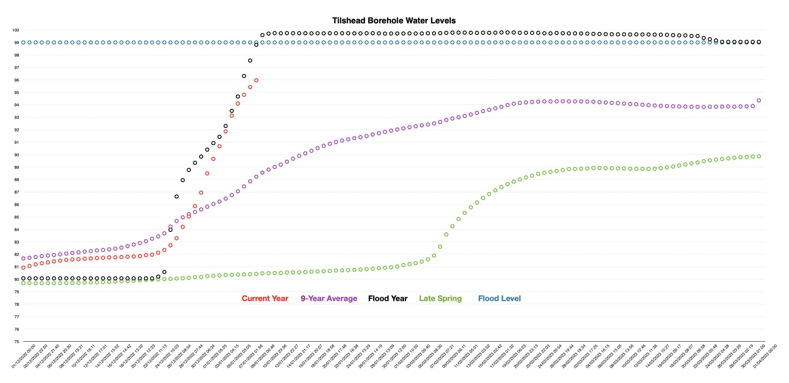
The water level today is almost 2 metres above the 9-year average, which sounds pretty dramatic, but needs a bit more clarification to be understandable. The detail behind that average is really rather interesting. Let’s look at the water levels in the aquifer on each 8th January over the last decade.
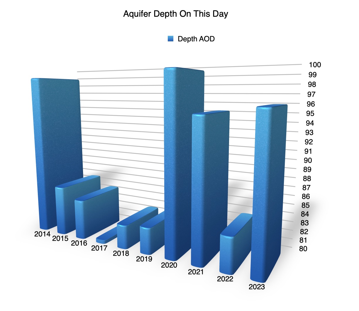
In 60% of years, the water depth on this day has been 85 metres AOD, or less. Today, the level is the third highest for an 8th of January in the last decade. The obvious question is does that mean we are likely to see flood alerts (a flood just might happen), or flood warnings (a flood will probably happen imminently) issued by the Environment Agency? It might be worth looking at the data over the last 9 years. It’s not easy to represent this graphically, so I’m afraid I’ve had to use a table.
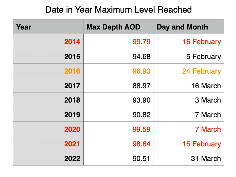
The years in red were years in which flood alerts were issued. The winter of 2016-2017, shown in orange, didn’t have a flood alert issued but is one of the highest annual maxima in the previous 9 years; the fourth highest. If you compare the table with the graph above, you will see that 2 out of 3 flood years had higher levels on the 8th of January than this year. That all goes to suggest that we are likely to have flood alerts issued at some point this year, and the obvious question is when might that happen? The table shows that over the last 9 years, irrespective of when flood alerts and flood warnings were issued, or actual flooding occurred, the maxima were reached in flood years between 15th February and 7th March; that’s a 4-week window.
Now look back at the first graph and the black line.; that is the 2013-2014 flood year. The Environment Agency considers that water levels in the aquifer are normal until they exceed 99 metres AOD, so flood alerts are given when the water level is approaching 99 metres AOD and flood warnings are issued when the level exceeds 99 metres. The 99-metre level was first exceeded on the 9th of January 2014 and stayed above it until the 25th of March. However, the peak level wasn’t reached until 16th February after nearly a month of flood warnings. So, the question of when might a flood alert be issued this year is one that is very difficult to answer. Rainfall is the key and when, and how much, will influence the rate the aquifer fills. Over the last decade, the single biggest leap in water levels was in 2014 when they rose almost 3 metres in a single 24-hour period. On the other hand, peak levels in flood years have happened as late as the 16th of February. So the best and most detailed prediction I’m prepared to make at this stage is as follows:
- As there is rain predicted in the coming weeks, and based on the historic data, we are going to move towards flood conditions at some point this winter.
- It’s the rain on the Plain that is important to the aquifer, not the rain in Winterbourne Stoke or to our south.
- It’s sunny outside, with intermittent showers, so although there is a historical precedent for a 3-metre daily rise that would take us above the 99-metre mark, it isnt going to happen today.
- So, all things considered, we will probably get an Environment Agency Flood Alert within the next six weeks, but maybe as early as the middle of next week.
I’d almost forgotten the River Till. Groundwater flooding doesn’t automatically mean that the river will flood, although they are closely linked. The Till is about 15-30cm (6 inches to a foot) from topping its banks to the south of the village. Heavy rain could make that happen very quickly, due to runoff as the ground is saturated. However, slow and steady rainfall could delay it considerably; but with water levels rising in the meadow, I think it is likely to happen sooner rather than later.
It’s worth taking a quick look at the aquifer immediately to our west, based around Chitterne and the Chitterne Brook. A groundwater flood alert was issued for the Chitterne Valley last week and a flood warning was issued on 6th January. The top of their normal range is 98 metres (ours is 99 metres), yet their maximum is 108.84 metres (ours is 99.88 metres) and their current level is 102.16 metres as opposed to our 95.96 metres). It rather goes to show the knife-edge situation of our aquifer at this time of year; it is 10 times more sensitive that the Chitterne aquifer. Chitterne Brook is part of the River Wylye system and a flood alert was issued for the Wylye and its tributaries on the 6th of January. That may have an effect on the lower reaches of the Till in the next few days.
So after that marathon, what is the weather going to do over the next few weeks? Well, wet and windy, I’m afraid. That applies to today and for much of the week ahead. This mix of drizzle, rain and windy conditions now seems likely to persist until early February, with temperatures being above average.
Should the Environment Agency issue any flood alerts, or warnings, they will be repeated here and on the village Facebook and WhatsApp groups. Please note that the Parish Council has no resources of its own with which to help villagers in the case of flooding. Some help may be available from Wiltshire Council (see: https://www.wiltshire.gov.uk/civil-emergencies-flooding) but affected households are advised to take their own precautions. In the worst case, the government has provided the following links: https://www.gov.uk/help-during-flood
As in previous years, your fellow villagers will help when and where they can. Don’t be backward about coming forward if you need that help!